Friday, August 31, 2012

Some Sol 24 Anaglyphs

 
  The Sol 24 full Navcam images have nearly completely downloaded from Mars. I used them to put together a few anaglyphs showing the view from near the top of the first crest to the east. The anaglyphs were focused at the center of the left image and both the left and the right images were contrast enhanced separately with the same pixel values as the upper and lower limits for the enhancement.


Stability of Slopes

 
  With Curiosity on her way to Glenelg one of the potential hazards is slippage on a slope. The critical angle for stability on a slope is referred to as the angle of repose. It is connected with landslides and avalanches. For sand dunes and barchans which are formed by aeolian processes the steeper slope is the slip face and is inclined at the angle of repose. This angle also determines the slopes of sand volcanos and mud volcanos. It is possible that the slopes of Gale Crater were formed by these processes and that warming of the surface induced instabilities. Liquid water has greater mobility than ice and buoyancy forces will cause it to move to the surface. So in a period of warming one would expect more geological activity. It should also be noted that the ground temperature at Gale Crater is now near the melting point of water.
 
  Supplemental (31 Aug): The varying slopes in Gale Crater suggests the possibility of microclimates in the area which might be of interest.
 

Sunday, August 26, 2012

Sculpted Rocks

 
  One of the Mastcam raw images contains a number of apparently sculpted stones with some much smaller rounded pebbles. Here's a full color version of the image.
 
 
  What does the scene tell us? The larger stones could be ventifacts formed by wind blown particles through a process known as saltation. Another explanation might be dislodged particles accelerated by gravity as they move downslope. Ignoring momentum lost by collisions the terminal velocity is a function of the angle of the slope, θ. The following plot gives the terminal velocity as a function of the slope for a small sphere 1cm in radius and a density of 3gm/cm3 for average conditions on Mars.


Saturday, August 25, 2012

Anaglyphs From Mastcam Images

 
  It's a little more challenging but one can make anaglyphs from the raw mastcam images. The difficulty is that the right image has about 3 time the resolution as the left image. But one can crop and resize the left image so both images cover the same field of view. Even though the left image isn't as detailed it still has some 3D information that is needed to construct the anaglyph. The eye can compensate some for defects in vision.


Panorama From Sol 17 Raw Images

 
  Ten of the Sol 17 Mastcam raw images were converted to color images and then merged into the following panorama. The enlarged image is about 6/10ths of the original. A number of horizontal breaks in the scene can more easily be detected by the greater detail and the abrupt changes in the texture.


One Small Step...

In memoriam, Neil Armstrong 1930-2012

Wednesday, August 22, 2012

Today's MSL Press Conference

 
  NASA held another live press conference this morning updating Curiosity's progress. The images and videos can be found on the MSL multimedia pages. In case you haven't heard Curiosity successfully completed her test movements. It looks like she will be going places. The first drive tracks give an indication of what the surface is like. It appears to be somewhat compacted since the tires do not sink too deeply into it. It's probably not as firm as asphalt but there are sections where the wheel cleats barely make a mark. It does appear to have a thin coating of loose material. The drivers will be checking for slippage. It wasn't mentioned but desert pavements can be formed by aeolian precesses which might explain why the wheels don't sink into the surface.
 
  The spectrum from the ChemCam experiment shows the composition of the rock dubbed Coronation. It appears to be a basalt similar to pyroxene. Hydrogen appears to have been present on the surface since it only showed up on the first "zap." It may be a contaminant sticking to the surface of the rock possibly associated with a widespread airborne material resting on the surface.
 

Tuesday, August 21, 2012

Anaglyphs from Navcam images - part 2

 
  I made some more anaglyphs from the Sol 2 Navcam images last night. The original Navcam images are 1024x1024 but I had to trim strips on the sides where the left and right protions weren't common to both images (no stereo). The original images appeared to be rather dark so I enhanced them with a image editor using the adaptive lighting, brightness and contrast tools. They were then reduced in size to about 700x700 so that Google would permit an enlarged view. I later put the entire set together using Autopano Pro to produce a fairly realistic 5 MB B&W stereo panorama that this blog probably would not accept in its original form.


Sunday, August 19, 2012

Anaglyphs from Navcam Images

 
  I did some anaglyphs using images from the left and right Navcams taken on Sol 2. One can more easily see the distance changes as one looks farther away from Curiosity. It's clear that one cannot see the downward slopes on the far side of the undulations.


  Supplemental (20 Aug): I noticed this morning that Emily Lakdawalla did an anaglyph on Aug 8th so my anaglyphs are old news but they help see the topography to the east in the direction of Glenelg a little better . The raw images are filed under Engineering cameras. The left and right images appear to be slightly rotated relative to each other. I used some rocks as the focal point for the anaglyphs and close attention to detail without glasses shows that the blue images on the left side are a little higher relative to red than on the right. Do the cameras themselves have a tweak for this so that one does not have to correct by rolling one of the images?
 

Saturday, August 18, 2012

MSL Landing Site Contour Map

 
  I did a contour map of the area containing the MSL landing site and Glenelg, the first science objective, using Google Mars. The distance between neighboring lines is an indication of the direction and how steep the slope is at a point. The elevations for the contour lines range from -4480m farthest out from the MSL position to -4430m near the little peak. It's not what one would expect looking at the shading on the image of the surface. The map was done manually using the ruler path tool. Google Earth might look into adding a contour mapping tool. It could be useful for planning traverses to take advantage of the terrain.


Friday, August 17, 2012

Risk Assessment for a Vista Capture

 
  Before trying to capture a vista panarama on the other side of the crest one needs to assess the risks involved. The main problem on a slope is slippage. One needs to determine the angle at which slippage will occur. For this one needs to know the coefficient of friction between the rover's wheels and the surface it is on. The coefficient of friction, μ = Ffriction/Fweight, is the ratio of the force at which friction occurs to the force of the weight of the material on a level surface. Slippage occurs on a slope of angle θ when the component of an objects weight along the surface is greater than the frictional force or when,
 
  Fweight sin(θ) > μ Fweight cos(θ).
 
This simplifies to tan(θ) > μ. The angle of slippage as a function of the coefficient of friction is shown in the following plot.
 
 
  The rover was designed to climb 45° slopes but the operational limit is 30°. This requires that at least μ > 0.6. However there are some soft materials like graphite, gypsum and chalk which can have low coefficients of friction of about 0.2 or so. Graphite is used as a lubricant and materials at the lower end of the Mohs scale may cause a problem on slopes. Sand is also a problem since its cohesiveness is very low and the MER rovers got bogged down in "sand traps." If one does not know the strength of the materials involved one would have to assume the worst and the angle of slippage for the softest materials which limits how far down a slope that one could go safely. Curiosity needs to be sure she won't lose her footing.
 

First Science Target: Glenelg

 
  NASA hosted another press teleconference today with two members of the science team. Dr Grotzinger is the MSL project scientist and mentioned that the first scientific objective of the mission will involve a traverse to Glenelg to the east of Curiosity's present position. Roger Wiens will be testing the ChemCam in the next week. It's laser will "zap" a rock designated N165. During the conference Emily Lakdawalla asked about a vista opportunity along the way and Dr Grotzinger said they could do that. Google Mars' elevation profile for the traverse shows a change which is a little more than the few meters stated. The greatest slope is about 25% or 14° at the Glenelg site which is within the 30° limit set for Curiosity. The rover drivers may need to be on guard against slippery slopes. A surface polished smooth by grit in the wind and some rounded pebbles may pose a hazardous condition for the rover.


Thursday, August 16, 2012

Getting a Better View of Curiosity's Surroundings

 
  Do the mission planners need more information to decide on a path to take them around the sand dunes and allow them to study features of interest along the way? The job could be done on the fly but I might be better to consider what could be done initially. The image below shows elevation profile along the crest and there is a high point about 315 m along a heading of 130° from the landing site. If one goes a little farther along that heading one will reach a "vista point" at 376 m from which one will get a better view of the lowlands. The Google Mars "targets of interest" contain a link to a MSL Workshop slide show presentation on a traverse of the area and points of scientific interest along the way. Curiosity could work her way to the vista point to gather topographic information of the lowlands from there while the opportunity is available then work her way north along the crest. From there she could study the lighter colored region to the east of the alluvial fan and then move west to the targets of interest on the alluvial fan and do something similar to the indicated traverse. In the process Curiosity could collect 3D panorams from different points of view.


Crests, Troughs and Waves on a Beach

 
  A I have mentioned that at a teleconference on Tuesday a reporter asked if one could cross the sand dunes over an apparent land bridge in one of the images shown. The problem is that there appears to be a crest to the south of Curiosity's position which prevents us from seeing all of the ground between Curiosity and Mt Sharp. There also appear to be ripples on the ground and breaks where the apparent size of the pebbles and rocks changes. To get a better idea of what is happening I drew some radial lines from Curiosity's position with the ruler tool and found that their height changed with distance when view from the side at an angle. When saved the radial lines are shown on the sidebar in Places. The Elevation Profile for a line can be viewed by right clicking on the line and selecting Show Elevation Profile in the drop down menu. The profile for the dark green line which has a heading of 150° is seen in the image below. It is roughly along the line of sight for the NASA/JPL image. The red box marks the boundary of quadrangle 51.
 
 
  If one looks at the profile one can see that there is a peak near the rover's position and this is what may be blocking our view. I marked the line of this crest with the letter C in the image above. There is also a trough along the line of sight that occurs just before where the "dunes" begin. The dunes appear to be breaking on the lower slope of Mt Sharp like waves on a beach. The reporter may also have been asking if MSL could find a path along the elevated strip at the base of Mt Sharp in order to reach the lower slopes.
 
  If Curiosity moved to the crest and traveled along it she would get a better view of the downward slopes and this may help to determine the best path for her to follow in the days to come.
 

Wednesday, August 15, 2012

Update on Curiosity's Position

 
  Using the latest image showing Curiosity's position from today's teleconference and 2D interpolation I was able to get a slightly better position. The points marked in red below supplied the connection between the image pixel points and Google Mars coordinates.
 
 
  The new coordinates are -4.589468° N, 137.441616° E. At the teleconference it was asked if the rover could cross an apparent land bridge to reach Mt Sharp but Curiosity appears to be in a bit of a hollow and one probably cannot see some of the dunes. Also the area to the right of Curiosity appears to be a bit of a rise and may block a view of the object to the east which was used to find the position. Curiosity may be able to see more if she moves to higher ground.
 

Tuesday, August 14, 2012

Reconciling Maps With The Real World

 
  We are conditioned to orientate ourselves relative to the objects in our environment and have a mental map of where things are relative to each other. We follow paths, trails and roads which take us from one place to another. But our primary sense of direction is that in which we are facing, that of forward. There are also left and right and up and down. All are determined visually. Then here are the directions north, south, east and west which are determined by the motion of the Sun and are less subject to change as we move about over larger distance scales. This is the basis for our primative sense of navigation. It is that of the naive impressionist observer and the pilot who are both focused on the real world. When specifying a course for a pilot it is best to maintain this perspective and specify the course in terms of waypoints and headings since geographic coordinates are somewhat abstracted from the real world. Survey maps are drawn to scale but treating the coordinates as plane vectors will only work correctly if by accident the scale of both directions are the same. One of the jobs of the navigator is to maintain the correspondence between a reference coordinate system and the pilot's 3D picture of his world (supported by instruments) through the points of contact that form the connection.
 

Navigating Near the Poles

 
  If one looks at the Pythagorean Theorem for spherical coordinates which specifies the approximate distance between two points one will notice that it breaks down at the poles where changes in longitude do not correspond to a change in distance. There is also a problem with the formula for a heading since these are defined relative to the direction of north. The reason for this is that the spherical coordinate system is defined relative to the equator and could be called equatorial spherical coordinates in which the primary directions are along the equator and towards the pole. One could define a polar spherical coordinate system for use in a hemisphere. We would use the same meridians but we need another parameter to measure distance. The natural choice would be the distance along a meridian from the pole. The heading in this system would be defined as its relative direction to the that of the prime meridian. One could use parallel transport of the heading to the pole while keeping the angle relative to the meridian constant to more clearly specify the definition. The angle of the heading would then be its angle relative to the meridian of a point plus the angle of the meridian. So one sees that at the poles the longitudes become the headings. One could define Cartesian coordinates in a tangent plane at a pole by choosing 0° and 90° longitude as the two axes. In the tangent plane the Pythagorean Theorem for small changes becomes
 
  Δs2 = Δr2 + (rΔλ)2    or    Δs2 = Δx2 + Δy2
 
assuming Δλ is measured in radians. Similar changes would need to be made for reference ellipsoids.
 
  Supplemental (14 Aug): The azimuth for a direction might better be defined as the angle relative to a meridian passing through a point. The angle that defines latitude can be extended beyond the north pole along a great circle so there is still a reference direction to measure the azimuth relative to at the pole. It has to be clear what meridian one is using.
 

Monday, August 13, 2012

Navigating by Latitude and Longitude

 
  Navigation is easier if one can use just latitude and longitude to specify positions. Though the grids are not quite square there is the equivalent of the Pythagorean Theorem for distance and a correction for the true heading can be found. Here are some simplified formulas that can be used. The flattening for the ellipsoid is f, the geocentric latitude is φ and the geographic latitude is φg.
 
 
  The formula for the heading correction has a factor, κ, which is a simple function of the scaling factors in the Pythagorean Theorem. The following calculations give the corrected headings and distances for the Google Mars points used to find Curiosity's position. Points were chosen that could be easily spotted on both Google Mars and the photographic images of the landing site. The first three are associated with the nearby craters and the forth appears to be a large boulder or sarsen of some sort. It seems to cast a good shadow. It also might make a good marker.


Sunday, August 12, 2012

Quadrangle 51

 
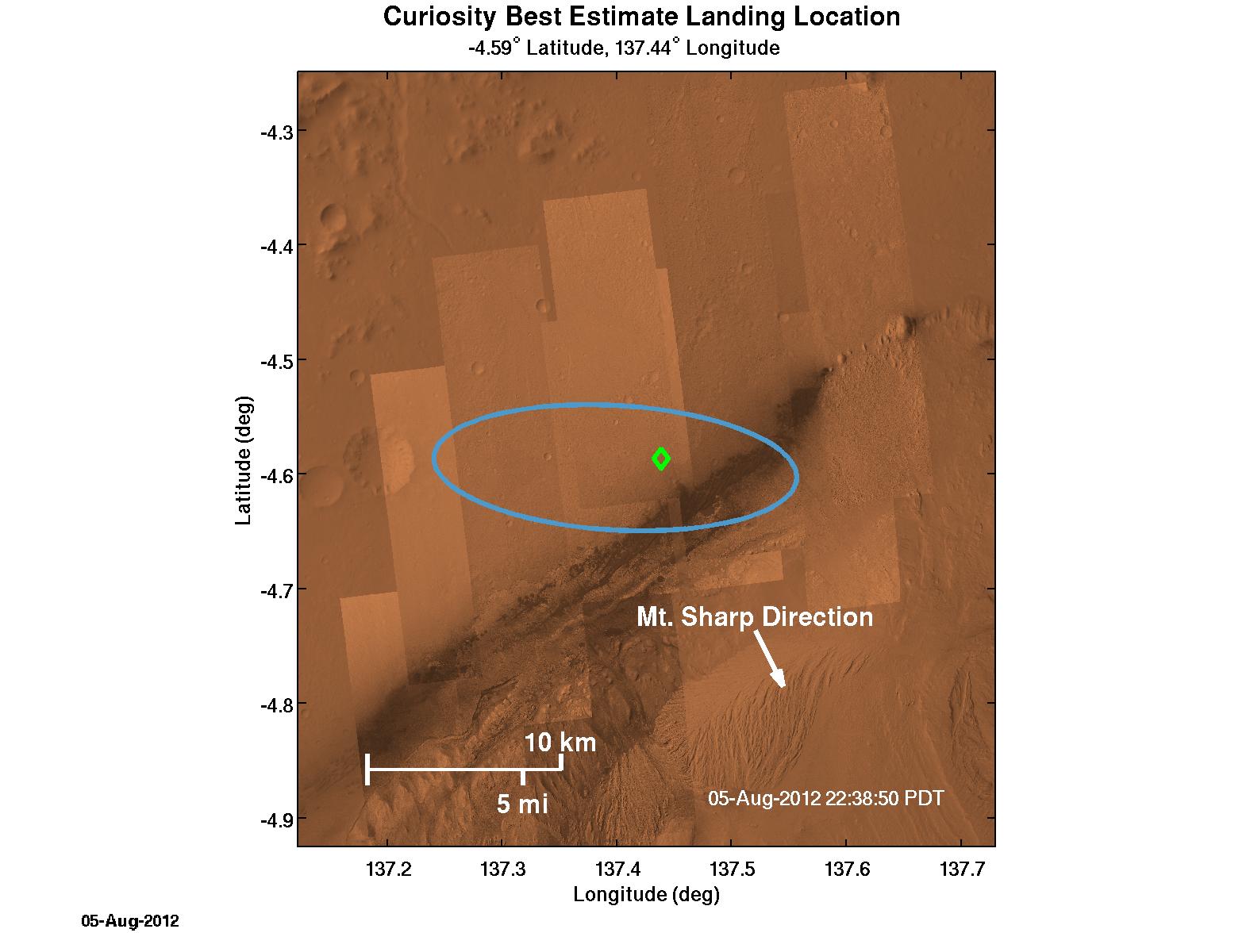
  The area about Curiosity's landing ellipse was divided into 140 quadrangles measuring 1/40th of a degree on each side. The actual landing site was in quadrangle 51 which is shown in this image. There are placemarkers showing where the upper left corner of each quadrangle is.
 
 
  In terms of distance the quadrangle is approximately square but somewhat rectangular with a linear conversion factor of about 60km/deg or 1km/amin. The averge values for the horizontal and vertical sides found by taking measurements in Google Mars and calculated using the ellipsoid for Mars are shown in the following image. The calculated conversion factors for changes in longitude and latitude are slong and slat respectively. The factor slat assumes geographic latitude. The linear approximation for the distance, Δs, between two points specified by angular coordinates would be,
 
  Δs2 = slong2 Δlong2 + slat2 Δlat2.
 
 
  The difference in scale in the two directions doesn't affect the result for the point where two lines of position intersect since λ, the fraction of the distance between the two ends of a line where the intercept is found, is not affected by a change of scale in either direction. I don't understand the discrepancy between the two results. Perhaps Google, JPL or the University of Arizona could help there. The calculation doesn't seem to be significantly affected by the distance below the ellipsoid. The figure of Mars is somewhat eggshaped with the southern pole radius a few kilometers less than that for the northern pole. But that shouldn't affect the equatorial region significantly.
 
  The procedure for finding the intercept appears to be invariant w.r.t. changes in scale.
 
  Supplemental (12 Aug): Headings are not invariant w.r.t. changes in scale lengths so headings computed using angular coordinates are only approximate. They should be computed for a plane in which all directions have the same scale of length.
 

Saturday, August 11, 2012

Identifying Visual Objects Using Google Mars

 
  Using the ruler tool in Google Mars one can identify and locate objects seen in the panaramas. One example is a northern peak along a heading of 345° and 77.3 km distant which checks with the angle shown in the annotated panarama. Coincidentally the channel for the alluvial fan is also along the heading. There is a small peak along a heading of 61° that appears to be 13.9 km distant and one can tell that it is a lot closer than Gale Crater's Rim because it is less obscured by haze. The lowest point on Curiosity's side of Mt Sharp, which I labeled the Sump, is also along 61°.


Thursday, August 9, 2012

Headings and Ranges from Google Mars

 
  One can use Google Mars to find directions and distances for objects in the first MSL panarama to help with their identification. The annotated version has degree markings on it from which one can determine the approximate bearing to an object.
  If one knows the coordinates for an object one can compute the bearings like I did in the second method for finding a position. The formula that I used in Mathcad was a little complicated and distracting at the time so this is how it was done. The formula uses relative directions to compute the angle determined by three points.
 
 
  One can check the bearing and distance of a known position in Google Mars by using the placemark tools to mark positions and then the ruler to determine the relative bearing and distance. This is helpful when trying to identify peaks of other features in a panorama.
 
 
  Supplemental (9 Aug): The formula for finding the azimuth can be simplified by using just the differences instead of the unit vectors. Originally I was thinking in terms of the projections of one unit vector on the other and its normal.
 

How Can Curiosity Determine Her Own Position?

 
  A position line can be determined by a known point and its direction instead of using two points. One can use a variation of the previous method for finding Curiosity's position if the bearings of two known objects can be determined. One replaces Δ1 and Δ2 with unit vectors representing their directions and Δ3 is again the difference between the two positions. The calculation proceeds as follows using two of the known positions from the last blog and their calculated bearings from the determined position.


Wednesday, August 8, 2012

Calculating Curiosity's Position

 
  I used a HIRISE image of Curiosity on Mars to obtain a better estimate of her position from two intersecting lines. To choose the lines I used a ruler to pick two points on objects on opposite sides of Curiosity's position so that the line passed through it and marked them red in Paint. The coordinates of these points were found on Google Mars using the placemark tool. The solution for the position, X, involves finding the intersection of the two lines which is,
 
  -4.58944°N, 137.44159°E.


Tuesday, August 7, 2012

Upcoming Science at Gale Crater

 
  Right now the engineering team is carefully checking out Curiosity to ensure that she is working properly. The onboard systems need to be activated one by one and put through their paces. The task may take several weeks to accomplish. Then the rover will be turned over to the science team and they will start working on the science objectives for the mission. Navigation and Mission Design Manager, Michael Watkins, touched on this at today's press conference.
 
  One topic that was briefly mentioned is the alluvial fan on the western slope of Mt Sharp. There are a number of channels to the south of Curiosity's present position that need to be investigated. The Google Mars positions of two of these are -4.84°N, 137.425°E and -5.12°N, 137.24°E. They can be seen from Curiosity's current position using "Street View" in Google Mars.


HIRISE Spots Curiosity on Mars


  At the JPL Press Conference at 10 am PDT this morning it was announced that HIRISE had captured an image of Curiosity on Mars. The updated coordinates for "her" position on Google Mars are -4.5893°N, 137.4416°E. The mast will be raised tomorrow and Curiosity will then start on a panarama of the surrounding area.
 

Monday, August 6, 2012

Where Is Curiosity?


  Curiosity's landing site can be seen on Google Mars. The coordinates of the position shown on the estimated landing ellipse are -4.59 N, 137.44 E. Curiosity made a descent video on the way down and you can clearly see the darkened area in the image above. It has an excellent view of Mt Sharp from this position.
 
  The mood at JPL was ecstatic last night when confirmation was received that Curiosity had safely landed.
 

Saturday, August 4, 2012

Less Than A Day Til Touchdown for Curiosity


  Mars Science Laboratory is rapidly approaching Mars and will touch down at Gale Crater in less than 24 hours. Here are the times for some key EDL events Sunday evening.
 
 Cruise Stage Sep
   10:14:37.9 pm PDT
 
 Entry
   10:24:34.6 pm
 
 Touchdown
   10:31:45.2 pm
 

Friday, August 3, 2012

Curiosity Lands On Mars This Weekend

 
src: JPLnews
 
src: JPLnews
 
  Mars Science Laboratory is due to land at Gale Crater on Mars at 10:31 pm PDT this Sunday. EDL (entry, descent and landing) takes about seven minutes. Curiosity's mission is not to search for life on Mars but rather the materials necessary for life and the geological evidence of their presence. One can preview and follow the events in real time using the Java application at Eyes on the Solar System.